Severe weather swept through Montgomery County and surrounding areas on Tuesday afternoon, leading to multiple updates from local authorities regarding tornado and severe thunderstorm warnings. Currently, some trees have been reported down, but Clarksville Police spokesman Scott Beaubien confirmed that there have been no reports of significant damage or injuries. The local power companies are managing outages effectively, with CDE Lightband reporting only 166 customers without power and CEMC noting 459 outages in Montgomery County.
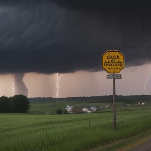
The situation initially escalated with a Tornado Warning issued for northern Montgomery County, warning residents about a severe thunderstorm capable of producing a tornado near Fort Campbell. The storm was tracked moving east at 45 mph, accompanied by quarter-size hail. The National Weather Service advised those in affected areas to seek shelter in sturdy buildings and to avoid windows.
As the storm progressed, authorities issued additional warnings. A Tornado Warning was canceled, but a Severe Thunderstorm Warning remains in place, covering areas extending from Elkton to Ashland City, with forecasts predicting possible 60 mph wind gusts. Residents reported sightings of a tornado near Peachers Mill Road and Tiny Town Road at approximately 5:20 p.m., although no damage has been confirmed.
The risks associated with severe weather were noteworthy, as the county was under an Enhanced Risk (level 3 out of 5) for severe storms, which could include large hail and damaging winds.
In terms of outlook, the weather forecast shows the potential for continued showers and thunderstorms throughout the evening, with a high temperature around 83 degrees predicted for the day. The chance of precipitation remains high, up to 90% for the afternoon, decreasing to 60% into the night before clearing up for a sunnier Wednesday.
Stay informed and prioritize safety as the severe weather continues to develop in the region. Local authorities are monitoring the situation closely and will provide updates as necessary.