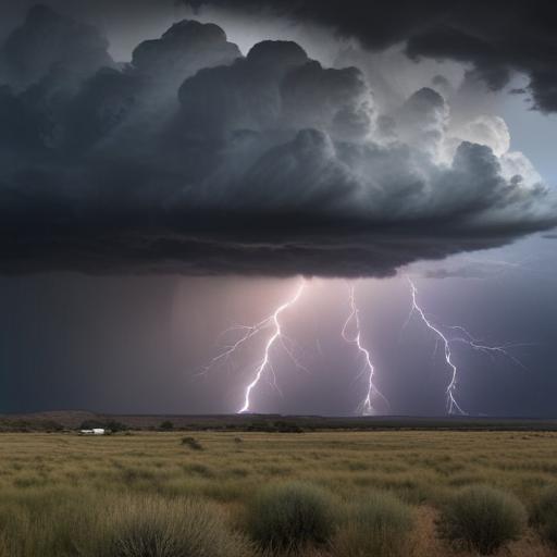
Severe thunderstorms are anticipated across Southern Colorado on Wednesday, with the Pikes Peak Region seeing initial storm formation between 12-2 PM. These storms are likely to escalate in intensity as they move eastward, raising concerns for damaging wind gusts reaching up to 70 mph and hail measuring up to 2 inches in diameter, particularly affecting the eastern Plains. The possibility of brief tornadoes is also in the forecast.
As the severe weather threat subsides between 7-8 PM, lingering showers are expected to continue into the late evening. On Wednesday, temperatures will be warm across the area, with highs landing in the 70s and 80s. Specific forecast highlights include:
– **Colorado Springs**: High of 73; Low of 47. Thunderstorms will develop early this afternoon, bringing the potential for severe conditions and significant hail.
– **Pueblo**: High of 80; Low of 49. Light morning sunshine will transition to scattered thunderstorms later in the afternoon, with risks of hail and strong winds.
– **Canon City**: High of 79; Low of 51. Strong thunderstorms are possible, although severe threats will be less than in other regions.
– **Woodland Park**: High of 67; Low of 40. Thunderstorms are forecasted to develop around lunchtime, with several rain rounds expected throughout the day.
– **Tri-Lakes**: High in the 60s and 70s; Low in the 40s. Storms may become severe early in the afternoon.
– **Plains**: High in the 70s and 80s; Low in the 40s and 50s. A Weather Alert is in effect for the potential of severe thunderstorms, with strong gusts and large hail expected.
In the mountains, expect milder conditions with highs in the 50s and 60s, though storms producing heavy rain, lightning, and gusty winds are still on the table.
Looking ahead, Thursday may bring residual clouds and a possibility of fog and drizzle early, particularly for the Pikes Peak Region as attendees arrive for the USAFA graduation ceremony. Chilly temperatures will be expected, with highs only reaching lower 60s post-cold front.
Friday forecasts a slight rebound in temperatures alongside a chance for scattered thunderstorms, with warmer highs in the 70s and 80s, and similar weather patterns will likely persist into the weekend, featuring mostly dry conditions on Sunday.
Preparedness is key for these weather events, and residents are encouraged to stay updated and remain alert for changing conditions.