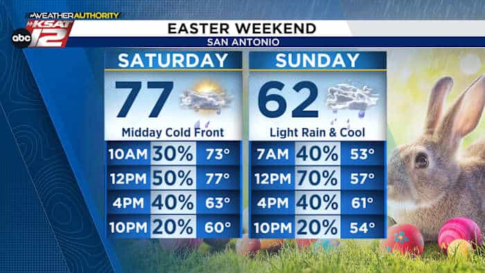
A sharp cold front will sweep through the San Antonio area Saturday around midday, bringing the highest rain chances of the weekend, gusty winds and a rapid drop in temperatures that will leave much of the region noticeably cooler for Easter. KSAT meteorologists say the front is expected to arrive between noon and 4 p.m., producing a roughly 60% chance of showers and isolated storms and wind gusts up to 35 mph.
Forecasters expect temperatures to fall quickly once the front moves through. Afternoon readings that start near typical spring levels are forecast to plunge into the 50s by Saturday night, with spotty showers lingering into the evening. The combination of wind and falling temperatures will make outdoor conditions feel blustery and chilly compared with earlier in the day.
Easter Sunday will be largely cloudy, chilly and damp across the metro area. Mornings should stay in the 50s, and on-and-off light rain is likely through the midday and early afternoon hours, with highs struggling to reach the low 60s. Rain is expected to taper off after about 6 p.m., leaving a cool, overcast finish to the holiday that will see temperatures dip back into the 50s overnight.
Rainfall amounts will vary sharply across South Texas. KSAT notes there will be a pronounced north-to-south drop-off in precipitation; communities in the Hill Country north of San Antonio may see little to no measurable rain on Sunday, while the heaviest totals will be farther south toward the Rio Grande Valley. Around the San Antonio metro, most locations should expect roughly half an inch of rain or less.
After the weekend’s brief surge of unsettled weather, a milder trend is expected for much of next week. Forecasts show temperatures warming toward the upper 70s to near 80 degrees with only a few scattered rain chances, signaling a relatively quick rebound from the cool, damp Easter conditions.
KSAT’s Your Weather Authority will continue to update timing and amounts as models refine the front’s speed and track. The weekend’s weather highlights — a midday Saturday cold front, gusty winds, scattered showers and a cool, drizzly Easter Sunday — reflect the region’s fast-changing springtime pattern.