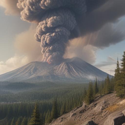
May 18, 1980, marks a significant moment in history for the Pacific Northwest, etched in memory as the day Mount St. Helens erupted with catastrophic power. While the eruption itself is widely acknowledged, the seismic activities leading to that day began weeks earlier, with earthquakes shaking the region as early as March. The first eruption in over a century occurred on March 27, marking the awakening of the long-dormant volcano.
Mark Smith, whose family operated the Spirit Lake Lodge near the volcano, recalled the excitement and uncertainty surrounding the events leading up to the eruption. Many locals, unfamiliar with volcanic activity, considered Mount St. Helens a mere geological curiosity until the situation escalated dramatically. As he observed the monumental eruption on May 18, he witnessed lahars, destructive mudflows that carved through the landscape.
Smith is among a few eyewitnesses who recounted their experiences to KATU for a documentary, alongside retired photojournalist Bob Foster, who faced dangerously close encounters with the eruption. Another account comes from Chris Ballew, who, alongside his family, found himself enveloped in the volcanic ash cloud while navigating home from Spokane to Seattle, illustrating the eruption’s vast reach.
In 1980, the landscape lacked a U.S. Geological Survey (USGS) office in the Northwest, which led to scientists from Hawaii and Colorado being dispatched to investigate the volcano’s unusual behavior. Dr. Jon Major from the Cascades Volcano Observatory explained that while the explosive potential of Mount St. Helens was recognized, the scale of the lateral blast that occurred on May 18 was unexpected. This event devastated roughly 230 square miles and unleashed mudflows that obliterated everything in their path.
The eruption resulted in 57 fatalities and destroyed more than 200 homes, amounting to over a billion dollars in damage. Research geologist Alexa Van Eaton reflected on the 1980 eruption’s global significance, stating it initiated a new era of volcanic research in the region. Two years later, Mount St. Helens National Volcanic Monument was established for research, recreation, and education, a step forward for understanding the volcano and its dynamics.
Jon Gellings from the National Forest Service highlighted the area’s unique landscape and the importance of heeding its lessons. The USGS Cascades Volcano Observatory, founded in 1982, today hosts a team of about 80 professionals who actively monitor Mount St. Helens. Such monitoring includes tracking seismic activity, gas emissions, and magma movements beneath the surface.
Currently, Mount St. Helens shows signs of normal background activity, without immediate threat of eruption. Research seismologist Weston Thelen explained that while background seismic activity involves minor earthquakes, it is significant when patterns change or unusual activity emerges. The last notable activity began in 2004, resulting in a series of small eruptions that concluded in 2008.
Interestingly, the observatory experts suggest that the likelihood of another eruption of the magnitude seen in 1980 is low, as the volcano has significantly changed since then. However, ongoing studies aim to better predict future eruptions, ensuring a proactive response is in place.
As the 45th anniversary of the eruption approaches on May 18, 2025, a public event will celebrate the history of Mount St. Helens at Spirit Lake Highway. The gathering will feature discussions led by various experts aimed at educating the community further. Though some nearby sites remain closed due to landslide damage, a glimpse of the volcano is available through an online cam, now operational again.
The history of Mount St. Helens serves as a reminder of the powerful forces of nature and the importance of preparedness and education in mitigating risks associated with volcanic activity. While the past was marked by tragedy, ongoing research and community engagement signify a positive path forward, emphasizing safety and awareness for the future.