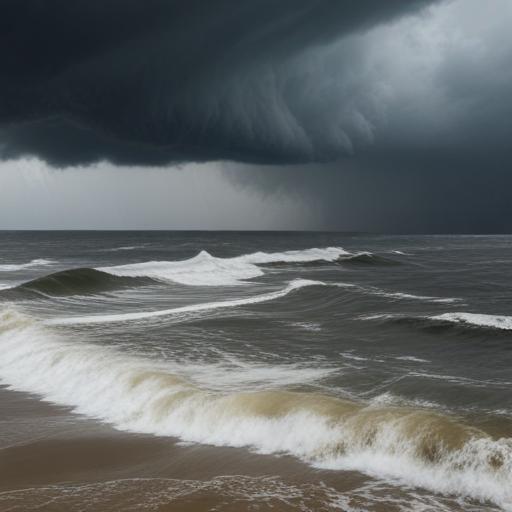
Hurricane Erin stays offshore, but the Virginia coast isn’t out of the woods yet
Hurricane Erin has intensified to a Category 2 storm but is forecast to remain over water, tracking between Bermuda and the U.S. East Coast. While the core of Erin won’t make landfall, its large swells are expected to push toward the East Coast through Friday, creating life-threatening marine conditions offshore and likely coastal flooding in the far eastern counties of Virginia.
A Coastal Flood Watch is in effect for the Middle Peninsula and Northern Neck from Thursday afternoon through Friday afternoon, with forecast inundation of 1-3 feet in the most vulnerable shoreline areas.
Forecast at a glance
– Wednesday night: Cloudy and muggy with a few showers and downpours. Lows in the low 70s. Rain chances around 30%.
– Thursday: Morning clouds with a few showers and drizzle. Breezy with north winds 10-15 mph and gusts up to 25-30 mph. Mostly cloudy afternoon with a passing shower possible. Highs in the upper 70s. Rain chances about 30%.
– Friday: Mostly sunny with a noticeable drop in humidity. Lows in the mid 60s, highs in the low 80s. Marked as the best day of the week by the forecast.
– Saturday: Beautiful and mostly sunny with low humidity. Lows in the low 60s, highs in the low to mid 80s.
– Sunday: Partly sunny with isolated showers and thunderstorms later in the day, more likely west of I-95 and closer to the mountains. Lows in the mid 60s, highs in the mid 80s. Rain chances 20% in the afternoon and 30% in the evening.
– Monday: Partly sunny with humidity easing in the evening. Lows in the mid to upper 60s, highs in the mid to upper 80s.
– Tuesday: Mostly sunny and pleasant with low humidity. Lows in the low 60s, highs in the low 80s.
– Wednesday: Partly sunny and pleasant. Lows in the upper 50s, highs in the low 80s.
Longer-range outlook
– First Alert guidance notes no signs of a return to extreme heat through late August, with temperatures expected to stay cooler than average as the month winds down.
What this means for residents
– Beach and water safety: Even without a landfall, Erin’s swells and rip currents pose significant dangers along coastlines. Heed lifeguard warnings and avoid swimming in rough surf or near jetties and piers when conditions are hazardous.
– Coastal flooding: The Coastal Flood Watch suggests risk of 1-3 feet of inundation in low-lying shoreline areas, particularly in the Middle Peninsula and Northern Neck. Plan for possible road closures and high-water conditions near coastal communities.
– Travel and planning: The weekend looks largely favorable in terms of sunshine and lower humidity, but showers and breezes can pass through at times. Have a flexible outdoor plan and monitor updates, as a quick coastal shift is possible with the storm’s outer bands.
Additional notes
– Weather app reminder: For frequent updates, download the First Alert Weather app (available in the Apple Store and Google Play) to track Erin’s position and local forecasts in real time.
Summary
Erin remains offshore as a Category 2 hurricane, bringing dangerous swells and coastal flooding potential to Virginia’s coast, especially in the eastern counties. A Coastal Flood Watch covers the Middle Peninsula and Northern Neck through Friday, while a mostly sunny and mild-to-warm pattern returns for much of the weekend into early next week. Stay informed with continuous forecast updates and heed safety guidance for coastal areas.
Commentary
– Forecasters stress that Erin’s coastal impacts can be felt even without a landfall, underscoring the importance of monitoring coastal advisories and preparing for possible coastal flooding and hazardous marine conditions. The forecast suggests a improving trend domestically by Friday into the weekend, but residents along the shore should remain vigilant through Friday as local effects can vary block by block.