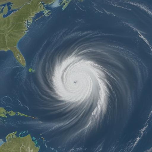
Erin strengthens into the first hurricane of the 2025 Atlantic season, reaching Category 4 status with maximum sustained winds around 130 mph on Saturday morning, the National Hurricane Center said. Tropical-storm watches are already in effect for parts of the Northern Leeward Islands, including St. Martin, St. Barts, Anguilla and Barbuda, with breezy, rainy conditions possible over the next 48 hours.
Forecasts indicate Erin could pass near or north of the Leeward Islands on Saturday, bringing up to about 6 inches of rain to the region on Friday and Saturday. The outer bands could also produce 2 to 4 inches of rain across Puerto Rico and the U.S. Virgin Islands over the weekend, with isolated flash flooding and gusty winds of 40 to 50 mph possible.
Erin is the first hurricane of the 2025 Atlantic season and could further intensify to a Category 4, with gusts potentially reaching 140 mph as it moves northwest. The storm is expected to stay east of the Bahamas, remaining well offshore of the U.S. East Coast for now. However, large waves and life-threatening rip currents are expected to reach the coast between Aug. 20 and Aug. 27, even as the storm remains offshore.
Coastal impacts are not just surf-related. The Outer Banks of North Carolina could face significant erosion and 8 to 12-foot waves, with waves of about 6 feet possible in parts of South Carolina and Virginia next week. A cold front moving off the U.S. coast is expected to steer Erin away from land and bring below-average temperatures to the Northeast next week.
forecasters have warned that the Atlantic hurricane season is predicted to be above normal, with August, September and October typically the most active months. The season runs through November 30.
What to know and safety tips:
– If you are in the Leeward Islands or along the U.S. East Coast beaches next week, monitor official advisories and avoid entering rough surf or rip currents.
– Do not rely on a single forecast; track updates from the National Hurricane Center, as Erin’s path and intensity can shift.
– Prepare emergency kits and review evacuation plans if you live near vulnerable coastal areas.
Summary:
Erin has become the first major hurricane of the 2025 season, posing rain and surf hazards for parts of the Caribbean and the U.S. East Coast while steering clear of direct landfall for now. The situation highlights the season’s active outlook and the ongoing need for coastal vigilance as Erin’s outer bands bring rain and dangerous waves to nearby regions in the coming days, with cooler air arriving on the back of a cold front next week. A hopeful note: the storm’s current trajectory suggests no immediate landfall, and cooler conditions are expected to follow.